submit images to Department of Ecology and participate in "citizen science".
Here is the DOE Flickr site - http://www.flickr.com/groups/1611274@N22/
Take a walk on the beach at your favorite Puget Sound site and sharpen your eyes and lenses.
Then send in your photos. (Also Of Paramount Importance would welcome some good shots to show off!) DOE would like to record your impressions to better study the impacts of these highest tides.
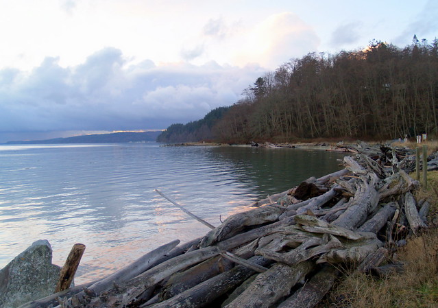 |
| photo submitted to DOE site by Cracklin Tulip |
Ala Spit, Whidbey Island, Jan 8, 2011 8:30 am. High Tide 11.28
About Washington King Tide Photo Initiative
The Washington Department of Ecology invites you to participate in the January-February 2011 King Tide photo initiative. This is the second year for the initiative. Its objectives are to:
1) Identify and catalogue coastal areas currently vulnerable to tidal flooding (inundation); and
2) Gather compelling pictures, to engage the public and build awareness of the specific potential impacts of sea level rise and storm surge on the Washington coast.
King Tides are extreme high tide events that occur once or twice a year when the sun and moon’s gravitation forces reinforce one another at times of the year when the moon is closest to the earth. King Tide events offer a chance to visualize what future sea levels may look like.
Coastal communities can monitor high tide and storm surge events to reduce potential damages and costs associated with these events in the future.Understanding the frequency and severity of high tide events, storm surges, and flooding is crucial in adapting to climate change.
Sea level is predicted to rise up to 50 inches in Puget Sound over the next century. Significant parts of Washington’s coast are already vulnerable to impacts caused by high water levels and storm surges due to their close proximity to the shoreline or low elevation.
For more information on king tides and climate change, visit Ecology’s King Tide Website. Sea level rise projections for Washington State are published in the report, Sea Level Rise in the Coastal Waters of Washington State (Mote, Petersen, Reeder, Shipman, & Whitely Binder; 2008).
The Washington King Tide Photo Initiative is part of a West Coast partnership with the Ecology’s King Tide Website and other partners in California and Oregon.
PARTICIPATE!
We invite you to submit photographs of coastal areas such as beaches, roads, parks and estuaries, known to be subject to flooding and erosion or areas where the high water levels can be gauged against familiar land marks, such as sea walls, jetties, bridges, dikes, buildings or other coastal structures. “Before and after” pictures showing average water levels and the extreme high water levels for the same location will also be useful.
1) Join this Flickr Group to view photos submitted from individuals around the state!
2) Take your own photos of king tides and add them to the flickr group!
King tide prediction information is available for certain communities in this table. If your community isn’t listed in the table, visit NOAA’s Tide Predictions website to find the dates, times and heights of tides in your area!
MORE QUESTIONS?
Feel free to email us your King Tide Questions.
Contact Ecology


No comments:
Post a Comment