| View of "Pier Park" including art, green plantings and beach in backround drawing provide by BRSE Point Wells |
 |
| Developers panel of experts answers questions submitted by audience. |
 |
Extensive Boardwalks and Bike Paths are planned drawing provide by BRSE Point Wells |
The first stage of bringing the vision to life has begun. Developer BSRE Point Wells, LP is working with the internationally recognized architecture firm of Perkins+Will to prepare initial community design elements for sharing and discussion with the community. And development management and representatives continue to meet with elected officials, staff and local residents to discuss how the development will be integrated into surrounding communities.Perkins, Will is the architecture firm doing the design led by Canadian Peter Busby.
 |
| Point Wells viewed from N-photo credit BRSE |
• LEED Platinum Goal for the project building standards with features such as rainwater catpure, cisterns, green rooves, vegetable/flower gardens, Community Center,
• Daylighted Creek with "aquaduct" to deliver the now piped stream over the railroad and associated wetland
• 20 acres of public open space
• 3 "Villages" to be built in phases
• Biomass Energy Plant
• Sound Transit Station
• Forested site leading to restored beaches with boardwalks and bike trails
• Green Park Pier with possible Water Taxi station and small marina for kayaks and small craft
• 3,000 housing units with varying heights. Some would be 180' in height, but would be out of view of Woodway and somewhat visible from RB.
Overall, it is vision for a virtual Disneyland of the North with all the features proposed. You can see the drawings and video proposal at the website http://www.pointwells.com/gallery/.
One major outstanding question we have is how will the developer accomplish the restoration of the polluted site? Apparently the plan is to retain all of the contaminated soils on site and "clean them up"
there. When asked "How would this be done", the reply was a somewhat simplified answer that it would be something like when an old gas station is removed and a spill is cleaned. In those cases, it often takes several years of "venting" and "burning off" the petroleum products. But nothing was said about other types of contamination such as from metals or asbestos which surely would be a factor. To be sure this would be a very complex clean-up project before any building would take place.
The other BIG question that the Richmond Beach Community members have is "how is this going to affect traffic in RB?" And perhaps "how can they get away with doing this?"
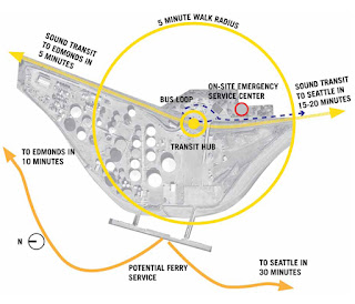
The BSRE answers are shown partially in this map. The public was invited to view the website
to review the images shown last night. http://www.pointwells.com/about-2/transportation/
 |
| Transportation Map supplied by BRSE website |
But, one wonders how these residents would earn a living enough to afford to live here? Presumably, they would have to leave the site in cars to commute to jobs in Seattle or other surrounding job hubs?
The estimated number of extra average daily "trips" generated up Richmond Beach Road would be about 1000 by 2020 and up to 10,000 by 2035.
But, not to worry BSRE seems to say. This won't even be completely built out until 2035! And all of us will be old or moved away by then!
So what is the next step?
The timeline shown by BSRE Point Wells is as follows.
• 2010-13 - Conceptual Design, EIS, and public outreach
• 2012-14 - Design Permitting
• 2012-19 - Phased Demo and Clean-up
• 2016-20 - Phased Construction and Community Infrastructure Development
Meanwhile Shoreline has passed a Subarea plan for Point Wells, filed an appeal in conjunction with Woodway and Save Richmond Beach, and is looking at possible options for annexation!
And Bills have been introduced in the legislature to encourage cooperation and the Shoreline Planning Commission has recently passed a plan to limit traffic on Richmond Beach Drive.
Shoreline Area News has the story on Bill proposed.
http://www.shorelineareanews.com/2011/01/evan-smith-ryu-expresses-support-for.html
This is just the beginning of a very long and fascinating process.
Fasten your seatbelts! Phew!
Janet


Has there been discussion yet about the risks of building so close to sea level. We are in ice melting and major storm times.
ReplyDeleteWhat unparadise sounding language do the developers have about this.
Would they want to build their homes on this site???
Looks like the non green company there previously has escaped the looming possibilty.